Study area
Highlands Wilderness Game Ranch is located in Limpopo (Northern Province), South-Africa, approximately 12 km northwest of the town Bela-Bela. The study area lies between 24°48’ and 24°59’ southern latitude and 28°09’ and 28°16’ eastern longitude (grid reference 2428 CC). The height above sea level at the ranch ranges from 1312 m to 1515 m. Size Highlands Wilderness Game Ranch is approximately 1300 ha. The research study excludes stand number 100 of approximately 70.76 ha, which is managed as cattle grazing. The game ranch is planned to have 99 houses after full development. The size of each house stand is 1.13 ha. Houses are constructed randomly throughout the ranch. The ranch is dominated by average to steep slopes due to the mountains on terrain. Grassland occupies a small area on the western side of the ranch. Infrastructure The basic structural part of the ranch is well constructed with roads access to most areas. The ranch is mountainous, with effects that roads cannot be constructed along the entire fence line. There are speed-limit signs and speed humps on the roads to reduce speed of vehicles. Most roads on the ranch are suitable for sedan vehicles, except on the southeast of stand number 86, the road is heavily eroded and only accessible by means of 4 x 4 vehicles. A number of houses are currently being constructed, most are located on the hills. The house owner’s visit occasionally; no owners reside permanently on the property, only staying a couple of nights per month. Stables for horses is also currently under construction at stand number 99 (Figure 1). There are fully equipped workshops, storeroom at stand number 1. The Game Ranch has only two water holes (Figure 1). The whole boundary of the ranch has been fenced using a standard 2.4 m game fence without electrification.
Climate
Climate is a major determinant of the geographical distribution of species and development of vegetation types (Tainton 1999). Local conditions of temperature, sunlight, humidity, and moisture vary greatly within any area of general climatic uniformity, and these factors play an important role in the production of plants and survival. On a small ranch, climatic changes such as rain, floods, drought, hail, frost, and wind should be measured or recorded on a regular basis (Van Rooyen and Theron 1998). The climate data was measured at the Towoomba weather station. For the period 1960 until 1996, data from the Towoomba weather station were used (station number: 17958; Longitude: 28° 33´S; Latitude: 24° 90´E; Altitude 1143 m above sea level). Climate data were obtained from Institute for Soil, Climate and Water (unpublished) ¹
Rainfall
Water is essential to the physiological and chemical processes occurring within the plants. It is also the medium by which nutrients in the soil are moved into plants (Burgoyne 1995). According to Tainton (1999) water is an important factor in distribution of a species and can be limiting factor in their occurrence. The annual rainfall over the whole country is relatively low and evaporation rate is high. Moisture stress is a factor that exerts a major influence on plant survival. The expected rainfall for the area is 450 to 700 mm. The information on rainfall was also obtained from Institute for Soil, Climate, and Water (Station number: 17958; Longitude: 28° 33´S; Latitude 24° 90´E; Altitude 1143 m above sea level). The mean annual rainfall is 630.5 mm as derived from long-term rainfall data from 1960 to1996, the highest mean monthly rainfall of 127 mm, occurring in December, and the lowest mean monthly rainfall of 2.7 mm, occurring in July (Table 1). The wet and dry season extends from October to April and May to September respectively (Figure 2). Short term data is important to evaluate the current status of the vegetation, for the project long term data is more important. It indicates trends, especially periodically occurring periods of droughts and wetness, and is the appropriate basis for grazing and browsing capacity calculations. Seasonality of rainfall pattern is an important aspect to consider. It has high influence on plant phenomenology and availability of food for animals. Table 1: Temperature and rainfall data of the Highlands Wilderness Game Ranch as determined from data of the Towoomba weather station
| Month | Mean monthly Maximum Temperature (°C) | Mean monthly Minimum Temperature (°C) | Mean monthly Rainfall (mm) |
| July | 21.5 | 2.9 | 2.2 |
| August | 24.4 | 6.0 | 5.0 |
| September | 28.2 | 10.6 | 12.4 |
| October | 29.4 | 13.9 | 58.4 |
| November | 29.1 | 15.5 | 99.9 |
| December | 29.5 | 16.5 | 127.1 |
| January | 30.0 | 17.2 | 9.0 |
| February | 29.5 | 16.7 | 74.1 |
| March | 28.5 | 15.2 | 34.7 |
| April | 26.4 | 11.5 | 10.7 |
| May | 23.9 | 6.6 | 5.0 |
| June | 21.1 | 3.3 | 2.2 |
| Mean annual Totals | 26.8 | 11.3 | 630.5 |
According to Burgoyne (1995) incoming radiation is the most fundamental parameter present in the environment of the plant. Temperature has a high influence on the survival of plants and influence the length of the growing season. Temperature is the controlling factor in the presence or absence of a species because plants can only function within a certain temperature range. As with most environmental factors, it is not the mean, but the temperature range that is important for the survival of the plants (Tainton 1999). In the area of Highlands Wilderness Game Ranch (Bela-Bela) summers are hot and winters are cold with possibilities of frost. The mean annual temperature as derived from long term data is 26.80 °C, the amplitude between the highest mean monthly maximum temperatures of 30 °C, based on the lowest and highest mean monthly minimum temperature of 2.87 °C is 27.13°C respectively. The maximum daily mean temperatures were recorded in January and the minimum daily temperatures in June (Table 1).
Topography
Topography is the general configuration of a land surface or any part of the earth’s surface, including its relief and the position of its natural and manmade features (Van der Watt and Van Rooyen 1995). Topography does not seem to have a direct influence on the composition and functioning of an ecosystem, but indirect influences may result however (Hugo, Viljoen and Meewis 1997). The angle at which the sun strikes a slope may for instance influence the vegetation on that particular slope. There is further a 1°C decrease in temperature with every 100 m increase in height above sea level. The orientation of slopes has a certain definite micro climatic influences on the distribution of plants and animals, while some orographic factors result in the formation of rainfall zones and shadow areas. Topography make clear the form of the landscape and is described by terrain morphologically units, terrain form and aspect and degree of slope. Terrain form is the physical character of an area and its configuration. Terrain morphological units are crest, escarpment, middleslope, footslope and valley bottom. The morphology of the terrain influences the soil development. The altitude of the study area ranges from 1308 m to 1515 m above sea level. Slopes on the ranch vary from flat (0-3°) to extreme (>45°). Steep slopes are, however, dominant slopes on the ranch with few flat slopes. The degree of slope is important because it affects the soil erodiability and water run-off. Slopes can further be divided as convex, plane and concave. Convex slopes are well drained, but concave slopes often show a degree of hydromorphism because of water accumulation (Van Rooyen and Theron 1999).
Geology
The distribution of geological formations on Highlands Wildernis Game Ranch was obtained by locating the area using Geographic Information System (GIS) computer programme. Granite, rhyolite and arenite geological formations are found on the ranch. Igneous rocks are formed when hot magma (molten mass of rock material) rises up from the lower crust or the upper mantle and then cools down and solidifies. Igneous rocks are further classified into either extrusive igneous rocks or intrusive igneous rocks. Extrusive igneous rocks are formed when magma that is ejected from the crust onto the surface of the earth, then cools down. An example of this is through volcanic eruptions. An example of an extrusive igneous rock is rhyolite, which is dominant on the ranch (Figure 3). Intrusive igneous rocks are formed when a molten rock mass (magma) cools down and solidifies beneath the surface of the earth. An example of an intrusive igneous rock is granite, which also occurs on the ranch. The two main factors that affect the nature of igneous rocks are the rate at which the magma cools down and the chemical composition of rocks. Depending on the conditions under which the magma cools, the igneous rock may be coarse-grained or fine-grained. Lava that cools down quickly forms igneous rocks with small crystals, fine grained. Intrusive igneous rocks usually cool down at a slow rate and form rocks with large crystals, coarse grained. The texture of rhyolite is fine grained or glassy and the most common minerals in this rock are quartz, feldspar and plagioclase. The texture of granite is coarse grained and the most common minerals in this rock are quartz, alkali, feldspar, plagioclase and hornblende. Arenite is an example of granite as well, is coarse grained granite that is very resistant to weathering makes up smaller part of granite (Hine and Hine 2006).

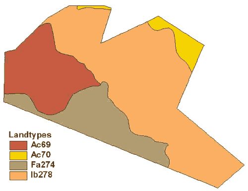
Soils
On Highlands Wilderness Game Ranch four different land types were distinguished, namely Ac69, Ac70, Fa274 and Ib274. The soil forms identified on the ranch were:
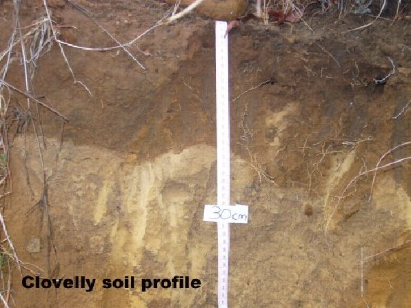
- Clovely: orthic A-horizon over yellow/brown apedal B-horizon
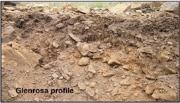
- Glenrosa: orthic A-horizon over a lithocuthanic B-horizon
- Hutton: orthic A-horizon over red apedal B-horizon
- Katspruit: orthic A-horizon over G-horizon
- Mispah: orthic A-horizon over a hard rock (Macvicar, Bennie, de Villiers, Ellis, Fey, Von Harmse, Hensley, Lambrechts, Bruce, Dohse, Eloff, Grey, Hartman, Idema, Laker, Merryweather, Michael, Schonau, Snyman, Van Niekerk, Verster, Loxton, Meyer, Paterson, Schoeman, Scotney, Turner, Van Rooyen and Yager 1991)
Soil, temperature and the availability of water is the most important factor determining the nature of terrestrial ecosystems. The soil profile comprises a series of horizontal layers of different chemical composition, structure, texture, or particle size, porosity, acidity, colour, and amount of organic matter. Soil can be defined as uppermost eroded layer of the earth’s surface, together with gases, water, dissolved inorganic salts, living organisms, and their remains that occur in this layer. Soil is the growth medium that supports almost all the terrestrial plant and animal life (Hugo et al. 1997). The specific plant communities and animal species found in a specific area are thus dependent on the type of soil and its properties. Soils forms characteristics on the ranch are explained as follows:
- Mispah – hard rock is weakly weathered and is a feature of shallow soils. Water and root penetration is extremely difficult in this soil type.
- Glenrosa – A lithocuthanic B-horizon shows minimal weathering of hard rock in vertical orientation; vertical tongues of relatively homogenous soil penetrate into a layer of hard rock.
- Clovelly – Properties of a yellow-brown apedal B-horizon are similar to those of a red apedal B-horizon. The difference in soil colour originates in the higher moisture content of Clovelly soils. This causes iron oxide coatings of soil particles to incorporate hydrogen and hence turn yellow in colour. Yellow apedal subsoil form easily from parent material as sand, sand-stone, quartzite, shale, and granite.


Hutton – This soil is characterised by reddish, weakly structured and well drained topsoil. The B-horizon is red as it is well drained, causing iron oxides to form coatings on soil particles. The lack of structural development (apedal) indicates the dominance of 1:1 non-swelling clay minerals. Non-swelling clays form easily from parent material such as gnesis and quartzite. These minerals have a low clay-forming potential, explaining the relatively low clay content of the Hutton soil form.
Katspruit – the G-horizon underlies a vertic, melanic or orthic A horizon, or an E horizon. The G-horizon has undergone loss of colloidal matter to the extent that the horizon has a more or less uniform grey or bleached colour and sandy texture. When the G-horizon occurs immediately beneath an orthic A, is the indication of the low chroma colours associated with wetness.
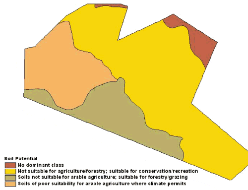
The Magaliesberg and Silverton Formations of the rocky ridge give rise to predominately the Glenrosa soil form on the slopes and some areas of the crest, while Mispah form will dominate rocky crests. On the low levels of the ranch, give rise to red-yellow freely drained, apedal soils, mainly the Clovelly and Hutton forms. Orthic A-horizons are the most common topsoil’s in South-Africa and they vary widely in organic carbon content, colour, texture, structure, base status and mineral composition. Red apedal B-horizons are soils with a weak structure. An advanced degree of weathering is indicated, which takes place in a well drained oxidizing environment. Clay minerals are dominated by non-swelling 1:1 types. Yellow-brown apedal B-horizons have many characteristics in common with the red apedal B-horizons. Differences are found in the colour caused by a higher average moisture status. Neocutanic B-horizons are usually of alluvial or colluvial origin and are often found close to the river. Lithocutanic B-horizons merge into underlying weathering rock. The in situ weathering of rock under the topsoil results in relatively well homogenised soil material without traces of weathering rock (MacVicar et al. 1991). Soil depth of Highlands Wildernis Game Ranch is between 450 to 750 mm deep (Figure 9). The soils found on the mountain slopes and rocky hills are not suitable for agriculture/forestry, but suitable for conservation/recreation. The majority of the plain is considered poor suitability for arable agriculture where climate permits
Vegetation
According to Bredenkamp and Van Rooyen (1998, In: Low and Rebelo 1998) the study area is situated in the sour bushveld of the Savanna biome. Sour veld bushveld represents a great variety of plant communities, with many variations and transitions. The vegetation varies from dense, short bushveld to a rather open tree savanna. The veld type is characterised by seasonal rain with a pronounced dry period and relatively low temperatures in winter. On shallow soils red bush willow Combretum apiculatum dominates the vegetation. Other trees and shrubs include common hook-thorn Acacia caffra, sickle bush Dichrostachys cinerea, live-long Lannea discolor,marula Sclerocarya birrea and various Grewia species. Trees like sickle bush, common hook thorn, red bush willow cause bush encroachment in some parts of the ranch, especially on the north facing slopes. The grassland on the north-western side of the ranch is dominated by common thatching grass Hyparrhenia hirta and yellow thatching grass Hyperthelia dissoluta. On deeper and sandier soils, silver cluster-leaf Terminalia sericea becomes dominant; with peeling plane Ochna pulcra, velvet raisin Grewia flava, weeping wattle Peltophorum africanum, and wild seringa Burkea africana are often prominent species. Broom love grass Eragrostis pallens and purple spike cat’s tail Perotis patens are characteristically present in the scanty grass sward. In the areas that are severely degraded the grass layer is dominated by forbs and sub-climax species (Bredenkamp and Van Rooyen 1998, In: Low and Rebelo 1998).
References
- BOTHMA, J. du. P. 2002. Objectives. Pp. 25-29. In: Bothma, J. du. P. (Ed). Game ranch management. Van Schaik Uitgewers: Pretoria. BOURGOYNE, P.M., 1995. Phytosociology of the north-eastern Transvaal high mountain grasslands. M.Sc. thesis, University of Pretoria. BREDENKAMP, G.J. and Brown, L.R. 2000. Vegetations – a reliable tool for environmental planning. Urban Greenfile. HINE, G. and Hine G. 2006. Level 1 Training manual. Professional nature guide development, Field Guides Association of Southern Africa. HUGO, M.L., Viljoen, A.T., and Meeuwis, J.M. 1997. The ecology of natural resource management. Kagiso, Pretoria. KENT, M. and Coker, P. 1994. Vegetation description and analysis. A practical approach. Chichester, Wiley. MACVICAR, C.N., Bennie, A.T.P., de Villiers, J.M.,
- Ellis, F., Fey, M.V., Harmse, J.J.M., Hensley, M., Lambrechts, J.J.N., Bruce, R.W., Dohse, T.E., Eloff, J.F., Grey, D.C.,
- Hartman, M.O., Idema, S.W.J., Laker, M.C., Merryweather, F.R., Michael, D., Schonau, B.H.A., Snyman, K., van
- Niekerk, B.J., Verster, E., Loxton, R.F., Meyer, J.H., Paterson, D.G., Schoeman, J.L., Scotney, D.M., Turner, D.P., van
- Rooyen, T.H. and Yager, T.U. 1991. Grondklassifikasie ´n Taksonomiese sisteem vir Suid-Afrika. Department van landbou-ontwikkeling, Pretoria. VAN DER WATT H.V.H., van Rooyen T.H. 1995. A glossary of soil science. The soil science society of South Africa, Pretoria. VAN ROOYEN, N and Bredenkamp G. 1996. Sour bushveld In: Low, A.B. and
- Rebelo, A.G. (eds.). Vegetation of South Africa, Lesotho and Swaziland. Dept. Environmental Affairs and Tourism, Pretoria. VAN ROOYEN, N. and Theron, G.K. 1998. Habitat evaluation. Pp. 75 – 77. In: Bothma, J. du P. (Ed.). Game ranch management. Fourth edition. Van Schaik Publishers: Pretoria.VAN ROOYEN, N. 2002. Veld management in the savannas. pp. 571-620. In: Bothma, J. du P. (Ed.). Game ranch management. Fourth edition. Van Schaik Publishers: Pretoria.
- TAINTON, N. M. 1999. Veld management in South Africa. University of Natal Press, Pietermaritzburg.